

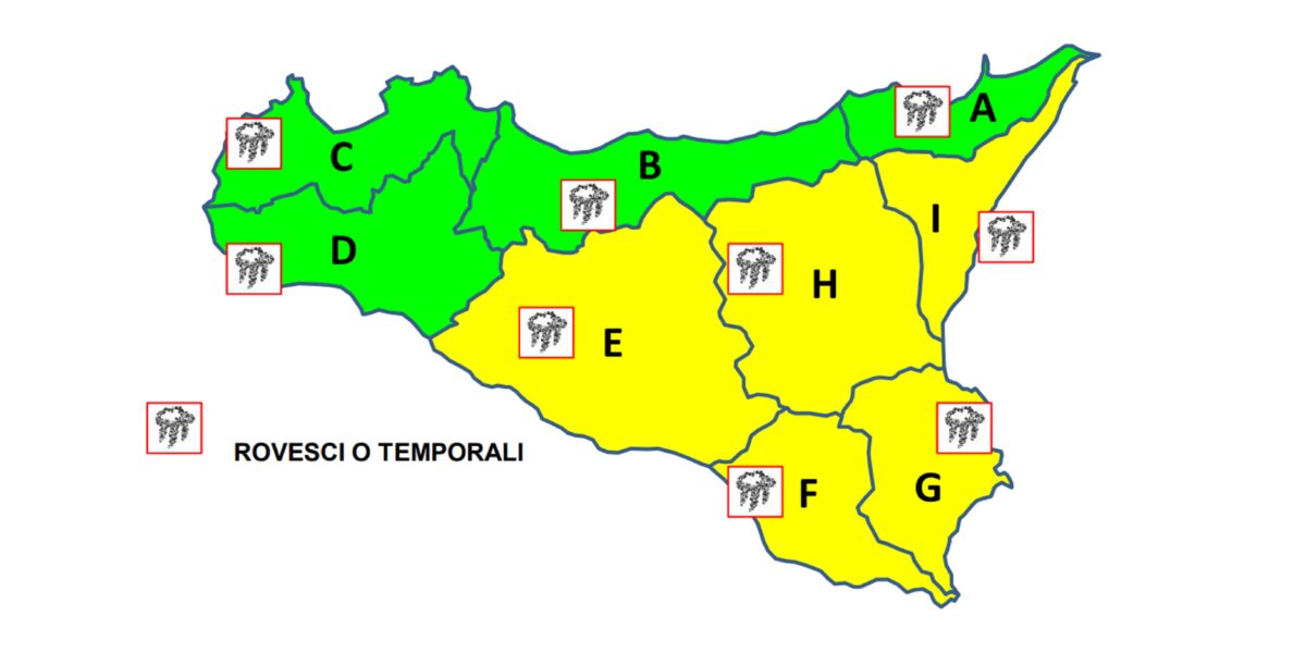
The yellow alert for hydrogeological and hydraulic risk linked to storms in part of Sicily remains in force for Tuesday 15 September. The new warning from the regional Civil Protection, valid from 4pm on Monday until midnight on Tuesday, includes zone I, corresponding to the north-eastern Ionian side of the island.
The alert therefore also affects the Ionian area of Messina. However, Messina city and the Strait, the Aeolian islands and the Tyrrhenian side of the province remain green. The green code indicates the absence of expected critical issues, but does not completely exclude the possibility of short and localized rainfall.
Yellow alert on the Ionian side of Messina
According to the regional bulletin, isolated to scattered rainfall is expected on Tuesday, including showers or thunderstorms. The quantities may be locally moderate in the internal, southern and Ionian areas of central-eastern Sicily, while in the remaining areas of the island they should remain generally weak.
Civil Protection recommends particular attention to flows in urban areas and in frequented places near watercourses. In fact, storms may develop in a localized manner and with rapid variations, making it difficult to identify the most affected locations in advance.
When can it rain on Tuesday in Sicily
The most favorable phase for the formation of the phenomena is expected between the middle of the day and the afternoon. Meteo.it forecasts indicate scattered showers and thunderstorms across Puglia, Basilicata, Calabria and the inland and south-eastern areas of Sicily. For Messina city the risk appears lower than in the provincial Ionian belt.
No significant wind and sea phenomena have been reported, while temperatures will remain without significant variations. The yellow alert will affect zones E, F, G, H and I of Sicily overall; zones A, B, C and D will remain green. There are no orange or red alert areas.